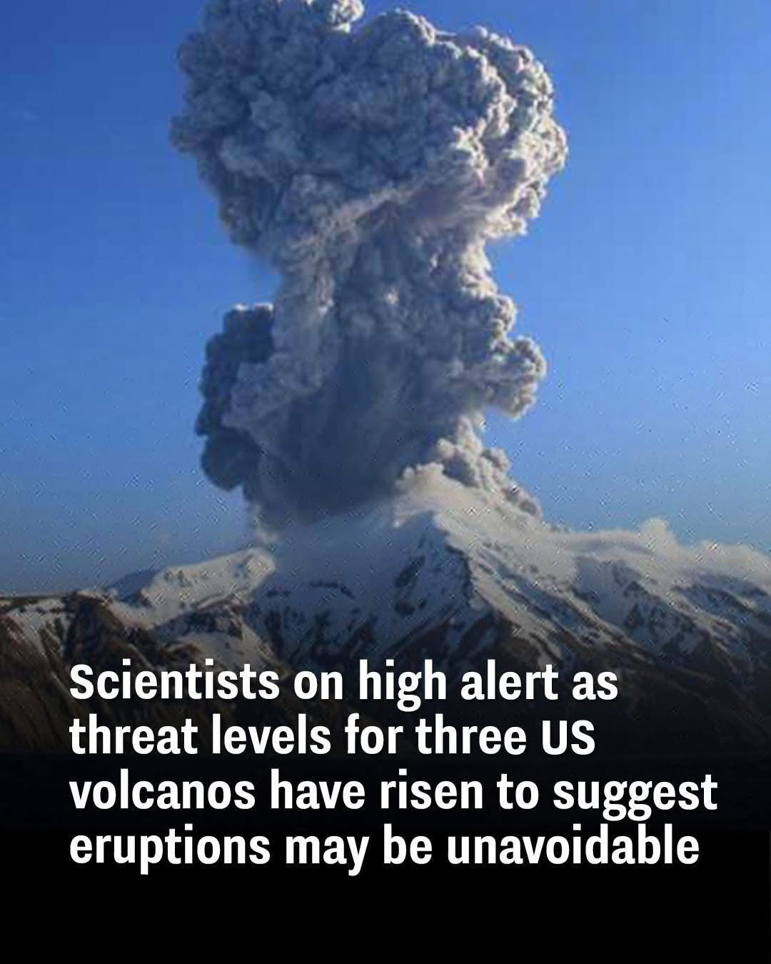
Scientists are closely monitoring three U.S. volcanoes—Alaska’s Great Sitkin and Mount Spurr, and Hawaii’s Kilauea—as seismic activity and eruption risks have escalated significantly. Authorities have raised the threat levels, signaling that eruptions may be imminent or unavoidable, urging nearby communities to prepare for potential volcanic events.
Heightened Volcanic Activity in Alaska and Hawaii

The U.S. Geological Survey (USGS) recently upgraded the alert status of Great Sitkin Volcano in the Aleutian Islands to “Watch,” the third tier on a four-level warning scale. This decision follows increased seismic tremors and observable lava emissions from the volcano’s summit crater.
Meanwhile, Mount Spurr, situated about 75 miles west of Anchorage, Alaska, has exhibited a marked surge in seismic events over the past year. Since April 2024, weekly earthquakes near the volcano have increased from around 30 to over 125, suggesting a 50-50 chance of eruption in the near term.
In Hawaii, Kilauea Volcano erupted on February 11, 2025, marking its ninth eruption since December 2024. The eruption sent lava fountains reaching approximately 300 feet into the air inside Hawaii Volcanoes National Park. While no residential areas have been directly affected, officials remain vigilant due to potential hazards from volcanic ash and volcanic glass particles.
Understanding the Signs: Seismic Activity and Magma Movement

Volcanic eruptions are often preceded by heightened seismicity, including earthquake swarms caused by magma moving through underground fractures. Scientists employ an array of monitoring techniques—such as seismographs, gas emission sensors, ground deformation measurements, and satellite imagery—to detect early warning signs.
At Great Sitkin, Mount Spurr, and Kilauea, sensors have detected increased ground tremors, rising magma levels, and changes in gas emissions, all indicative of rising volcanic unrest. These signs suggest magma is ascending closer to the surface, increasing pressure within volcanic chambers and raising the likelihood of an eruption.
Risks to Communities and Infrastructure

Rising magma beneath active volcanoes can lead to various hazards, including lava flows, explosive ash clouds, toxic gas emissions (such as sulfur dioxide), and ground deformation. These phenomena pose threats to local infrastructure, air travel, agriculture, and public health.
For example:
-
Great Sitkin: Its proximity to the Aleutian Islands raises concerns about air traffic disruptions from ash clouds and possible impacts on small local communities.
-
Mount Spurr: Given its closeness to Anchorage, an eruption could affect Alaska’s largest city with ashfall, impacting transportation, power supplies, and air quality.
-
Kilauea: Lava flows and gas emissions within Hawaii Volcanoes National Park could threaten nearby populated areas if activity escalates.
Emergency preparedness measures, including evacuation planning and real-time monitoring, are critical for mitigating the impact on these communities.
Learning from Past Eruptions

Scientists rely on historical volcanic activity data to interpret current unrest. The 1980 eruption of Mount St. Helens and Kilauea’s decades-long eruption cycles provide valuable case studies on precursors and eruption behavior.
By comparing current seismic and geophysical data with historical patterns, volcanologists refine eruption forecasts and enhance early warning systems, which are vital for protecting residents and property.
How Scientists Predict Volcanic Eruptions

Volcanologists combine multiple lines of evidence to assess eruption risks:
-
Seismic Monitoring: Increased frequency and magnitude of earthquakes indicate magma movement.
-
Ground Deformation: Swelling or sinking of the earth’s surface reveals pressure changes underground.
-
Gas Emissions: Changes in sulfur dioxide and carbon dioxide emissions help track volcanic activity.
-
Satellite Data: Thermal imaging and remote sensing detect heat anomalies and surface changes.
Integrating these data allows experts to issue timely alerts and inform emergency response efforts.
What Residents Should Know and Do

Officials urge residents near these volcanoes to stay informed through official channels such as the USGS Volcano Hazards Program and local emergency management offices. Preparation steps include:
-
Developing and reviewing evacuation plans.
-
Keeping emergency supplies ready.
-
Staying updated with alerts and advisories.
-
Avoiding areas prone to lava flows and ashfall during heightened activity.
Being prepared helps reduce risk and facilitates prompt action if evacuation orders are issued.
Conclusion: Vigilance and Preparedness Are Essential

With the increased seismic activity and elevated threat levels at Great Sitkin, Mount Spurr, and Kilauea, scientists maintain high alert status and continue rigorous monitoring. While the precise timing of eruptions remains uncertain, the potential hazards demand ongoing vigilance.
By combining scientific advances with community preparedness, officials aim to minimize the impact of volcanic activity on human lives and infrastructure.
Sources
-
U.S. Geological Survey Volcano Hazards Program: https://volcanoes.usgs.gov
-
Alaska Volcano Observatory: https://avo.alaska.edu
-
Hawaiian Volcano Observatory: https://volcanoes.usgs.gov/observatories/hvo/
-
Smithsonian Institution Global Volcanism Program: https://volcano.si.edu
-
National Oceanic and Atmospheric Administration (NOAA): https://www.noaa.gov/volcanic-activity